The Diurnal Cycle of Convection in a Mesoscale Model

Richard Neale and Julia Slingo

Centre for Global Atmospheric Modelling
Department of Meteorology
University of Reading
Earley Gate
PO Box 243
Reading RG6 6BB
UK


Aim: To diagnose the relationship between the diurnal cycle of convection over the maritime continent islands and the adjacent coastal regions using mesoscale modelling experiments. Furthermore, to use the results from these experiments as the basis for a sea/land breeze parametrization in a course grid atmospheric GCM.

INTRODUCTION ANIMATIONS
MM5 MESOSCALE MODEL PARAMETRIZATION
RESULTS SUMMARY

Introduction
Return to top
The Maritime Continent comprises the region of large islands separating the tropical Indian and Pacific oceans from 90-150 degrees east. The climate of the region is dominated by considerable convective activity on a wide range of scales from localised thunderstorms up to global-scale intra-seasonal variability associated with the Madden Julian Oscillation (MJO). This wide range of forcing scales has proved difficult to capture in global climate models (GCMs) and one of the more common errors is an underestimate of the time-mean precipitation averaged across the region.


Figure 1. The maritime continent region. Orography elevation increases from green through to dark brown colors.

Of particular interest is the role diurnal forcing plays in determining the variability and mean climate of the region. Observations show that the islands of the region heat strongly throughout the day whereas the adjacent separating seas with a much large thermal inertia restricts diurnal contrasts in temperature. However the diurnal cycle over land is able to lead to a large diurnal forcing of convection around the islands (Fig. 2.) Convection prevails through the tropics as can be seen in the annual average, but significant differences exist between the amount of rainfall during local AM hours (0000-1200) and local PM hours (1200-0000). Across the vast majority of the oceanic convective regions there is more rainfall during AM hours implying reduced stability during this time. However, coastal areas such as the Gulf of Guinea, west of Ecuador and, most notably, around all the islands of the maritime continent the AM minus PM rainfall difference is much greater. For this particular year of 1998 the rainfall falling during AM hours is more than three times greater than that falling during PM hours. The key point to address is that the coastal enhancement of AM precipitation and/or the suppression of PM rainfall is clearly linked to the geometry of the coastline and by implication the diurnal cycle of the nearby islands. The regions around the islands are also where the largest dry biases tend to occur in course-grid GCMs. Therefore, it is hypothesised that the dry bias in GCMs is, at least in some part, related to their poor performance in capturing the processes involved in the diurnal cycle.


Figure 2. SSM/I rainfall data showing the AM and PM peaks for the year 1998 and the diurnal differences.

Given that the diurnal cycle of the islands and adjacent seas appear to be intimately linked it remains to determine exactly how the atmosphere provides this link. Observations show that the existance of small-scale (order 10s of kms) sea-breeze circulations are able to lead to the formation of larger scale mesoscale convective systems. The peak of these systems often leads to the maximum in the diurnal cycle of precipitation throughout much of the tropics (see GOES-E satellite rapid scan animations over Florida Figure 3). As the July day progresses strong surface heating leads to the presence of small-scale cumulus over the whole land region. However, moving in from the coast preferential regions of enhanced convection form as the density current response to the land-sea temperature contrast leads to the formation of sea-breeze fronts. It is at seemingly random points along the sea-breeze front that strong convection extending throughout the depth of the atmosphere is triggered. This stong convection leads to mesoscale systems on larger spatial scales than the initial sea-breeze front. The gust-fronts from these systems are further able to preferentially trigger deep convection. Over the maritime continent these mesoscale systems are seen to propogate away from the islands and lead to a diurnal peak in convection after the time of the peak over the islands. The correct representation of this link between land/sea diurnal peak in convection is thought to be crucial in reproducing the observed mean and variability over the maritime continent.


MM5 Mesoscale Model
Return to top
In response to Met Office Unified Model (UM) experiments which give a dry bias over the maritime continent a number of regional mesoscale modelling experiments have been performed. The integrations are intended to investigate the model's ability to reproduce aspects of the diurnal cycle which were poorly simulated in the UM. The PSU/NCAR Mesoscale Model Vn. 5 (MM5) is a non-hydrostatic grid-point model widely used throughout the forecasting community and extensively used in a tropical setting. Successive nesting over a specified limited area is used in order to consistently scale down ECMWF Re-analysis (ERA) to the scales of interest that will capture sea-breeze type circulations. The model grid is centred over the Maritime Continent island of Borneo and successively nested as shown in Fig. 4.


Figure 4. The nested domains used in the MM5 experiments from the course 72-km grid down to the fine 8-km grid.


Each nest is run for 5 days from 1st-5th January 1993 taking its boundary condition from the adjacent larger domain. The largest domain with the coarsest grid-size (72km) is forced with 6 hourly ERA data. The standard set-up for each integration uses simple ice (Dudhia) moisture & micro-physics, an explicit cloud and clear air radiation scheme and the Mellor-Yamanda boundary layer scheme taken from the ETA model (Janic 1990, MWR).

One key difference between the maritime continent and the Florida convection shown in Figure 3 is the presence of significant orography. All the islands of the maritime continent have a central spine of mountains in excess of 2000m (Fig 5.). In particular we focus on Borneo which has a range of mountains extending from the north-east tip of the island to the centre. This is crucial since the diurnal cycle is almost certainly linked to the presence of orography through surface heating patterns and mountain wind flow behaviour.


Figure 5. The model orography used for each of the MM5 three domains.

A wide range of experiments have been performed. These include experiments to determine the most appropriate convection scheme to use, the effect of increased vertical resolution and the role of orography over the islands. A selection of results will be described here but the full set of experiments are listed below.

Full list of Experiments performed

01 - Betts-Miller Convection Scheme
02 - Grell Convection Scheme
03 - Kuo Convection-Scheme
04 - Kain-Fritsch (KF) Convection Scheme
0403 - L19 KF - Orography removed
0403o - L19 KF - Orography included
0404 - L19 KF with radius of updrafts halved from 1500m to 750m
0405 - L19 Convection scheme turned off for 8km domain
0406 - L19 KF with Blackaddar boundary layer regime scheme
0407 - L38 KF - Orography removed
0407o - L38 KF - Orography included

Results
Return to top

Choice of Convection Scheme

The diurnal cycle in the tropics intimately involves convective processes and their response to surface forcing. Therefore the choice of convection scheme is crucial if we wish to represent these processes at our resolution of interest. Of the four convection parametrizations tested the Kain-Fritsch (KF) scheme was considered to be the most appropriate at our resolution of interest. It has the most accurate distribution of precipitation with the land and oceanic maximum occuring at distinctly different times as shown in figures in the table below.
Run Scheme Description Plots
0101 Betts-Miller Relaxation adjustment to a reference thermodynamic profile over a given time ppn
0102 Grell Quasi-equilibrium, single cloud approximation, updraft/downdraft fluxes ppn
0103 Kuo Moisture convergence, column moistening depends upon relative humidity ppn
0104 Kain-Fritsch Relaxation to a profile due to updraft and downdraft, convective mass flux removes available buoyant energy in relaxation time ppn


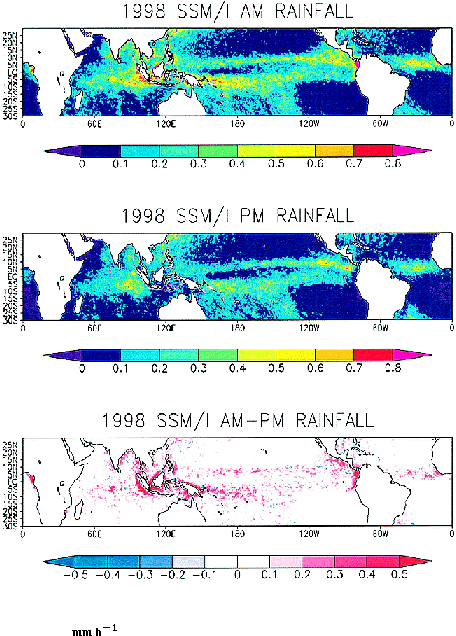
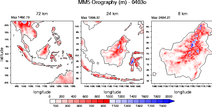
Table 1. Description of 4 convection schemes tested and a summary plot of the distribution of convection shown every three hours for one day of each run.

Sea Breeze Circulation

With the KF convection scheme the model captures the observed AM minus PM rainfall differences. Figure 6 and Figure 7 show that both the progression of the sea-breeze in-land and the observed maximum convection over the adjacent oceans are captured at the 24km and 8km resolutions. The main question we wish to address is the enhanced AM minus PM convection seen just off the coast in the model. By examining the differences between the experiments with and without orography (0407 and 0407o respectively) we can determine whether the presence of orography acts to enhance the off-coastal convective diurnal signal amplitude.


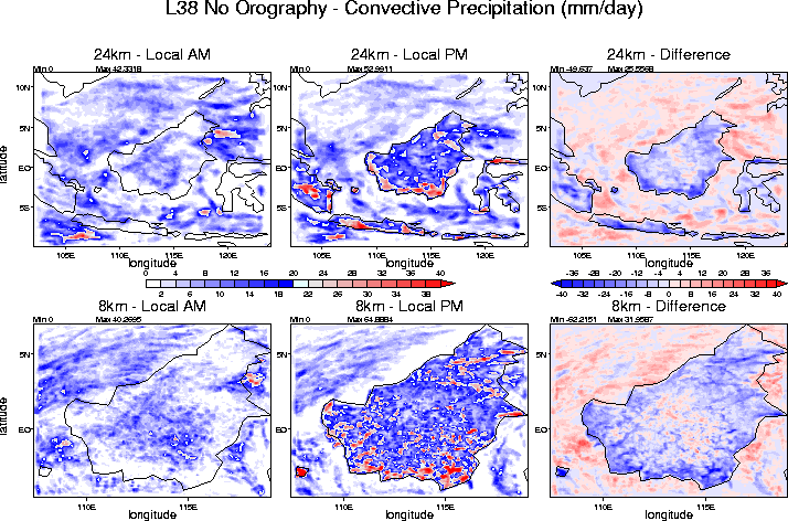
Figure 6. The local AM, local PM and differences in the 4-day average precipitation amounts for the 8-km and 24-km grid domains in experiment 0407. Orography not included.

In the absence of orography (Fig 6.) the model produces a clear progression of the sea-breeze from near the coasts during local PM to the centre of Borneo during local AM (this propagation can be seen more clearly in the Animations section). The progression is evident at both 8km and 24km resolutions. The effect this has on the off coastal diurnal cycle amplitude can be seen off the eastern coast of Borneo. Here the AM minus PM difference in rainfall is about 10 mm/day representing a large diurnal amplitude. Therefore, in the absence of orography it appears there is some association between the land and ocean diurnal cycle which leads to the off-coastal enhancement of the diurnal cycle.


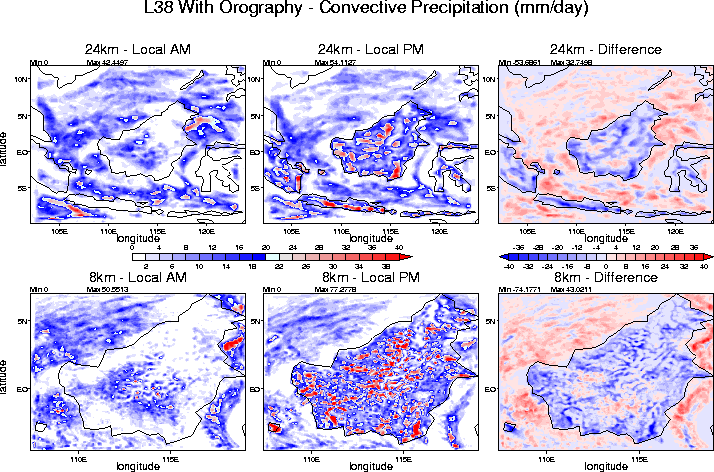
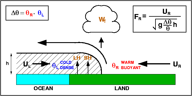
Figure 7. The local AM, local PM and differences in the 4-day average precipitation amounts for the 8-km and 24-km grid domains in experiment 0407o. Orography included.

With orography included (Fig. 7) the obvious sea-breeze progression as seen in the absence of orography is interrupted and localised orographic effects have a significant impact on convective organisation. However, the diurnal amplitude of precipitation in our region of interest - just off the East coast of Borneo - is increased above that seen in Fig. 6, particularly at the 8km resolution. Therefore, this suggests that the orography of the islands has a role to play in enhancing the coastal diurnal cycle of precipitation as seen in observations (Fig. 2).

Land Breeze Circulation?

The effect of included the orography on different aspects of the coastal diurnal cycle can be seen in Fig. 8 and Fig. 9. It highlights a possible role for the orography induced land breeze circulation.

The convective precipitation summarises the situation described in Fig. 6 and Fig. 7. Namely that the convection associated with the sea-breeze is stronger and has more coherent propagation in the absence of orography, and the coastal oceanic convective diurnal cycle is greater with orography. The major difference in the surface forcing between the two experiments is that the surface is able to cool much more effectively in the presence of elevated mountains such that just inland from the coast temperatures are up to 5 degrees cooler. After the associated cooling of the lower atmosphere during local dark hours a much stronger land-breeze circulation is established extending much further out from the coast. The low-level off coastal flow associated with the land-breeze opposes the ambient land-ward flow and creates a region of preferential low-level convergence and by implication more prevalent convection. This picture may be complicated by the existence of drainage flow from the mountain regions nut if anything this would add to the net effect of the land-breeze. Therefore it would seem the enhanced sea-breeze circulation can, at least in part, explain the existence of a stronger off-coastal diurnal cycle which is also situated further off the coast than in the absence of orography.


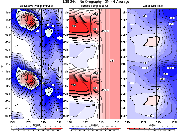
Figure 8. Mean diurnal cycle (repeated for clarity) for experiment 0407 (24km) during 2nd-5th January 1993 averaged between 2N and 4N for convective precipitation, surface temperature and near-surface zonal wind. The solid vertical line indicates the position of the mean coastline with land (Borneo) to the West and ocean to the East.


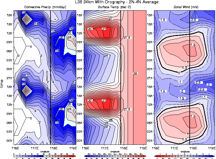
Figure 9. Mean diurnal cycle (repeated for clarity) for experiment 0407o (24km) during 2nd-5th January 1993 averaged between 2N and 4N for convective precipitation, surface temperature and near-surface zonal wind. The solid vertical line indicates the position of the mean coastline with land (Borneo) to the West and ocean to the East.


Animations
ONGOING SECTION The following section contains animations from preliminary experiments using the MM5 mesoscale model at 8km and 24km resolution. The animation are split into three different types.
  • SUP High frequency sampling every 15 minutes during the spin-up period of the first day of the experiments.
  • F4D Animations during the full 4 day period sampled every 3 hours.
  • MDC Animations of the average diurnal cycle for 4 days of each experiment.


Parametrization
Return to top
Results from the mesoscale modelling experiments indicate that the best way forward in addressing the short-comings of course grid-scale GCMs is to provide a parametrization of the diurnal effects associated with land/sea-breeze type circulations. This is necessary since GCMs are not able to explicitly model the observed diurnal variability around the tropical coastal regions which provides a significant proportion of the models precipitation mean and variability. Sea-breeze dynamics involves the formation of fronts which can trigger strong convection on much smaller scales than a GCM grid-box. Concentrating on the Met Office Unified Model (UM) the plan is to utilise the pre-existing coastal tiling system to provide an estimate of latent heating (LH), sensible heating (SH) and cloud base mass-flux changes (Wf) (Fig. 10) associated with a diagnosed pre-existing sea- or land-breeze. The existence of a sea- or land-breeze circulation will be determined from density current dynamics. Therefore, the grid-box boundary layer flow (UR) and land/sea temperature difference determine, through the Froude number (FR), whether a density current is able to exist. A more detailed summary of the theory behind a sea-breeze parametrization can be found here.

The complexity of the parametrization will depend on which of the following influencing factors are considered in the scheme:

Stability
Mean flow
Horizontal shear in the vertical
Coastal orientation
Sub-grid pattern of variability
Memory of previous sea-breeze activity


Figure 10. A schematic representation of an observed sea-breeze, shown with variables important for a GCM parametrization.


Summary
Return to top
Observations show a significant off coastal diurnal cycle of precipitation over the Maritime Continent

Enhanced when compared to the open ocean

Pattern is related to coastal geometry and therefore presence of islands

Co-located with large rainfall errors in the Unified Model

Scale interaction occurs whereby small scale sea-breeze circulations can lead to offshore mesoscale systems.

MM5 captures the observed AM/PM peak over ocean/land.

The magnitude of the coastal diurnal cycle is enhanced

The effect of including orography is to increase the magnitude of the coastal diurnal cycle still further

A stronger land breeze circulation due to the stronger surface cooling of an elevated surface leads to a land breeze which opposes the ambient on-shore flow giving increased low-level convergence

Future Work

Investigate the effect of two way nesting with the aim of trying to capture the scaling up from sea-breeze to mesoscales

Perform different case studies to diagnose the role of the ambient flow and whether on-shore or offshore flow is more conducive to enhancing the coastal diurnal cycle amplitude

In order to determine the required parameters to design a physically based sea/land breeze parametrtization idealised MM5 experiments will be performed with simplified islands and forcing conditions.