DARE is a European Union funded concerted action programme among whose objectives are:
![]() to co-ordinate the
interaction between European groups in order to build a capability in data assimilation
to process Envisat data for the atmosphere, and thereby to improve the quality
and cost-effectiveness of the data.
to co-ordinate the
interaction between European groups in order to build a capability in data assimilation
to process Envisat data for the atmosphere, and thereby to improve the quality
and cost-effectiveness of the data.
![]() to identify data products
that can be produced by data assimilation to facilitate the exploitation of
Envisat data by a diverse user community.
to identify data products
that can be produced by data assimilation to facilitate the exploitation of
Envisat data by a diverse user community.
Data assimilation is a technique whereby observational data are combined
with forecast fields from a numerical model, in order to produce an optimal
representation of the evolving state of the atmosphere (or ocean or other system).
The technique lies at the heart of present-day weather forecasting and climate
research.
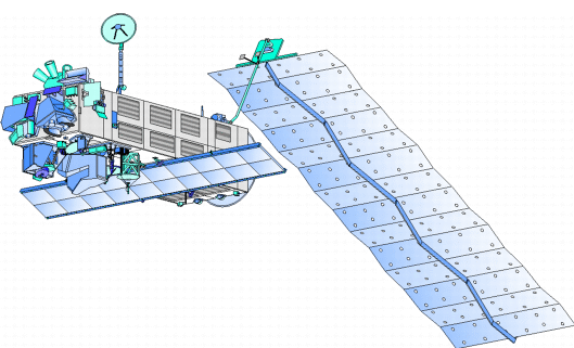
Envisat-1, will be launched in May 2000 by the European Space Agency (ESA). Envisat-1 is an advanced polar-orbiting Earth observation satellite which will provide measurements of the atmosphere, ocean, land and ice over a five year period.
The Envisat-1 satellite has a payload that will ensure the continuity of the data measurements of the ESA ERS satellites. The Envisat-1 data will support earth science research and allow monitoring of environmental and climatic change evolution.
Information from instruments (e.g. satellite measurements) and short-range forecasts of a numerical model are combined in a manner that allows for the errors in the observations and also those in the forecasts produced by the model.
Error statistics for the model and observations can be used to derive the most probable state of the atmosphere, consistent with both observations and model forecast. The procedure allows data void regions, in both space and time, to be filled. Continual ingestion of the observational data by the model helps to keep the (imperfect) model in a state that is in close agreement with the observations - the model ensures that the data are combined in a manner consistent with the equations that govern the evolution of the model.
Both the model and the measurements can profit from the assimilation procedure. Modelling problems can be identified, as they will manifest themselves in the form of large forecast errors. Similarly, the assimilation may provide information about the quality of the instruments and retrieval code.
 |
 |
Most assimilation techniques analyse measurements sequentially in time. When a measurement is imported into a model, the new (analysed) model field value will, generally, lie somewhere in between the observation and the forecast. After the measurement is assimilated the model field is propagated forwards in time until the next observation, and the procedure is repeated. In this way only measurements prior to the model time are assimilated.
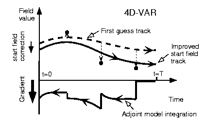
Another approach known as four dimensional variational (4dvar) data assimilation is now increasingly being used. Here, a penalty function that describes the fit of the observations to the model forecast over a time interval [0,T] is minimised. A first-guess model forecast is computed by running the model from the analysis at time 0 to time T. During this run the mismatches between the forecast and all measurements in the interval are recorded. Then a second (`adjoint') model is used which combines all the mismatches in the time interval in order to modify the analysis at time t=0, thereby allowing an improved forecast to be made. Typically, the above procedure is repeated several times to converge the analysed field towards the true state.
The evolution of the model field in the time interval is described purely by the model, and no jumps occur. Note that all measurements at all spatial locations in the interval [0,T] are taken into account in the single analysis. This results in a smooth behaviour of the forecast fields in the [0,T] interval.
3dvar may be considered as the limiting case of 4dvar when there is no time-dependency in the data. Advantages of 3dvar over other simpler (or `more traditional') sequential techniques are:
![]() 3dvar does not require
any data selection; it solves a global minimisation problem, using all the observations,
3dvar does not require
any data selection; it solves a global minimisation problem, using all the observations,
![]() it allows for easier
assimilation of satellite-measured radiances without the need for algorithms
to retrieve, for example, temperature or wind.
it allows for easier
assimilation of satellite-measured radiances without the need for algorithms
to retrieve, for example, temperature or wind.
Perceived advantages of 4dvar over 3dvar are:
![]() a large number of
observations can be analysed simultaneously,
a large number of
observations can be analysed simultaneously,
![]() additional information
from future observations is made available to the analysis,
additional information
from future observations is made available to the analysis,
![]() observations of one
quantity will influence other quantities via the model (e.g. ozone observations
may have a positive impact on lower stratospheric winds).
observations of one
quantity will influence other quantities via the model (e.g. ozone observations
may have a positive impact on lower stratospheric winds).
Much of the illustrative information on data assimilation used here was taken from Variational data assimilation: How to extract more information from GOME total ozone data by H.J. Eskes, A.J.M. Piters, P.F. Levelt, M.A.F. Allaart, and H. Kelder of KNMI, which is available at http://www.knmi.nl/~eskes/eoq/EOQ_article.html.
NASA Upper Atmosphere Research Satellite (UARS):
![]() Microwave Limb Sounder (MLS) - ozone, temperature
Microwave Limb Sounder (MLS) - ozone, temperature
![]() Improved Stratospheric
and Mesospheric Sounder (ISAMS) - temperature
Improved Stratospheric
and Mesospheric Sounder (ISAMS) - temperature
![]() High Resolution Doppler
Interferometer (HRDI) - winds
High Resolution Doppler
Interferometer (HRDI) - winds
ESA ERS-2:
![]() Global Ozone Monitoring
Experiment (GOME) - ozone
Global Ozone Monitoring
Experiment (GOME) - ozone
ESA Envisat:
![]() Global Ozone Monitoring
by Occultation of Stars (GOMOS)
Global Ozone Monitoring
by Occultation of Stars (GOMOS)
![]() Michelson Interferometer
for Passive Atmospheric Sounding (MIPAS)
Michelson Interferometer
for Passive Atmospheric Sounding (MIPAS)
![]() SCanning Imaging Absorption
spectroMeter for Atmospheric CartograpHY (SCIAMACHY)
SCanning Imaging Absorption
spectroMeter for Atmospheric CartograpHY (SCIAMACHY)
- these three instruments give data on ozone, temperature and atmospheric chemical
tracer constituents.
NASA Earth Observing System, EOS-CHEM:
![]() Earth Observing System MLS:
Earth Observing System MLS:
![]() HIRDLS:
HIRDLS:
![]() TES:
TES:
![]() OMI:
OMI:
- these instruments give data on ozone, temperature and atmospheric chemical
tracer constituents.
![]() MSDOL - Monitoring
of Stratospheric Depletion of Ozone Layer
MSDOL - Monitoring
of Stratospheric Depletion of Ozone Layer
![]() SODA - Studies of Ozone
Distribution based on Assimilated satellite measurements
SODA - Studies of Ozone
Distribution based on Assimilated satellite measurements
![]() ESA ESTEC: http://www.estec.esa.nl
ESA ESTEC: http://www.estec.esa.nl
![]() ESA's Envisat programme:
http://envisat.estec.esa.nl
ESA's Envisat programme:
http://envisat.estec.esa.nl
![]() NASA's EOS programme:
http://eos-chem.gsfc.nasa.gov
NASA's EOS programme:
http://eos-chem.gsfc.nasa.gov
![]() UARS: http://umpgal.gsfc.nasa.gov/uars-science.html
UARS: http://umpgal.gsfc.nasa.gov/uars-science.html
![]() SODA: http://www.knmi.nl/soda/
SODA: http://www.knmi.nl/soda/
Coordinators: William Lahoz , Alan O'Neill
NERC Centre for Global Atmospheric Modelling,
The University of Reading, UK
Using the UKMO data assimilation system for assimilation of temperature and
ozone from the UARS MLS instrument.
William Lahoz , http://ugamp.nerc.ac.uk/cgam/cgam.htm
U. K. Meteorological Office, Bracknell,
UK UARS assimilations (temperature, ozone and winds).
Partner in the SODA project.
Andrew Lorenc , http://www.meto.gov.uk
Université Pierre-et-Marie Curie, Paris, France
Chemical data assimilation (stratospheric profiles, tropospheric columns) with
chemistry transport models and trajectory models; GOMOS project investigator.
A partner in the MSDOL project.
Gérard Megie , http://www.ipsl.jussieu.fr
Koninklijk Nederlands Meteorologisch Instituut, De Bilt,
The Netherlands
Ozone chemical data assimilation with a global circulation model and a chemistry
transport model.
SCIAMACHY instrument principal investigator.
Coordinator of the SODA project.
Hennie Kelder , http://www.knmi.nl/onderzk/atmosam
Institut für Geophysik und Meteorologie der Universität zu Köln,
Germany
4dvar chemical data assimilation with a chemistry transport model.
Hendrik Elbern , http://www.uni-koeln.de/math-nat-fak/geomet/index.html
For further details visit the DARE website at http://ugamp.nerc.ac.uk/~wal/dare.html